
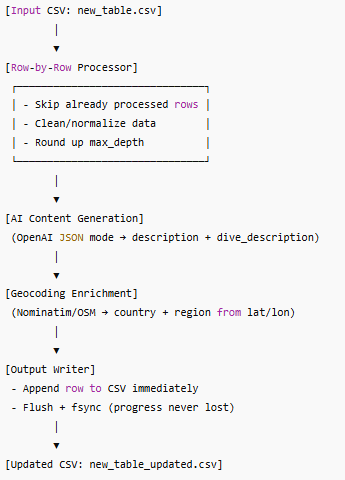
This project is a resilient data enrichment pipeline that processes dive sites one row at a time, enriching them with AI-generated content and geospatial metadata.
The system is designed for safety and reliability:
-
Reads an input CSV (new_table.csv) and appends results row-by-row to an output CSV (new_table_updated.csv).
-
Supports resume-on-crash by skipping rows already written.
-
Uses OpenAI Chat Completions (JSON mode) to generate two fields:
-
description (short location overview)
-
dive_description (detailed dive conditions, access, visibility, highlights)
-
-
Applies geocoding via Nominatim (OpenStreetMap) to fill missing country/region from latitude/longitude.
-
Normalizes and rounds up max depth values for consistency.
-
Flushes data after every row so progress is never lost.
This project demonstrates how to build a fault-tolerant ETL pipeline with AI integration, combining structured data cleaning, geospatial enrichment, and automated content generation into one cohesive process.
Have an idea that needs to work?
Discuss the next practical step with De Wilde ICT Solutions.
Contact us